
 Français
 Nederlands
 Deutsch
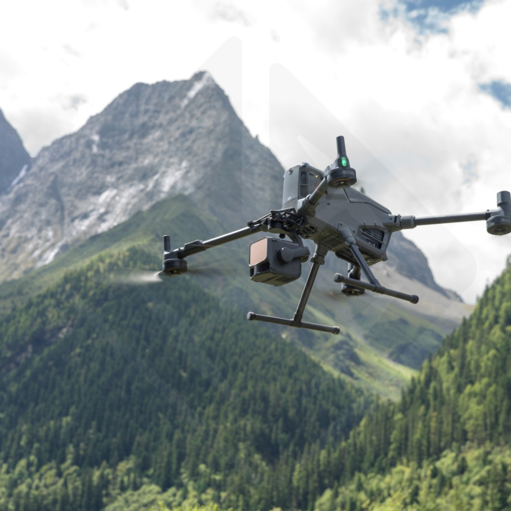
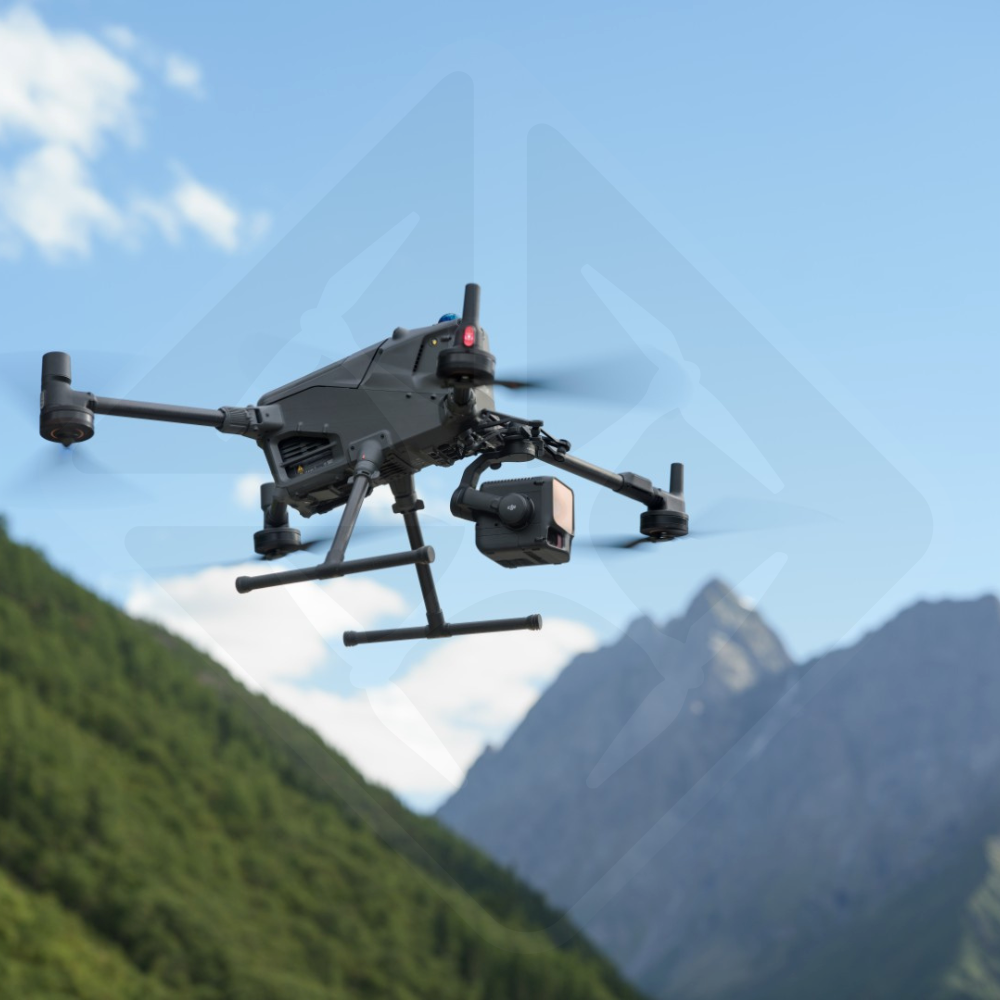
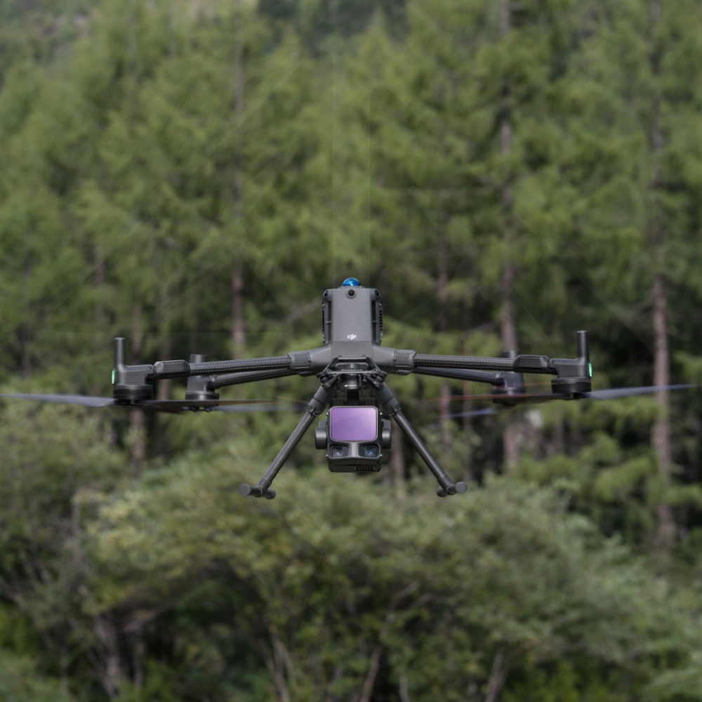
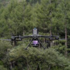
DJI Matrice 400 RTK – L3 LiDAR Survey Kit
€ 30.699,00

Revolutionize your surveying and inspections with the DJI Matrice 400 RTK and Zenmuse L3 Kit. This integrated solution offers centimeter accuracy, an extended LiDAR range of up to 950 meters, and unmatched operational efficiency, capable of covering up to 100 km² per day. Designed for surveyors, infrastructure engineers, and quarry operators, this kit transforms geospatial data collection with superior vegetation cover penetration and ultra-detailed 3D modeling.
In stock
This kit pairs the DJI Matrice 400 RTK with the DJI Zenmuse L3 LiDAR payload for survey-grade aerial mapping. Drone Parts Center assembles it for land surveyors, engineering firms and infrastructure managers who need a rugged flight platform and a latest-generation LiDAR sensor, configured and ready to fly.
A rugged flight platform
The DJI Matrice 400 is IP55-rated and flies from -20 to 50 °C (without direct sunlight). Its omnidirectional obstacle sensing, reinforced by LiDAR and millimetre-wave radar, makes flights near power lines and complex structures safer. The Zenmuse L3 mounts on its own dedicated single gimbal connector.
Zenmuse L3: accuracy, range and penetration
The Zenmuse L3 integrates a 1,535 nm long-range LiDAR, a high-accuracy POS system and two 100 MP 4/3 CMOS RGB mapping cameras.
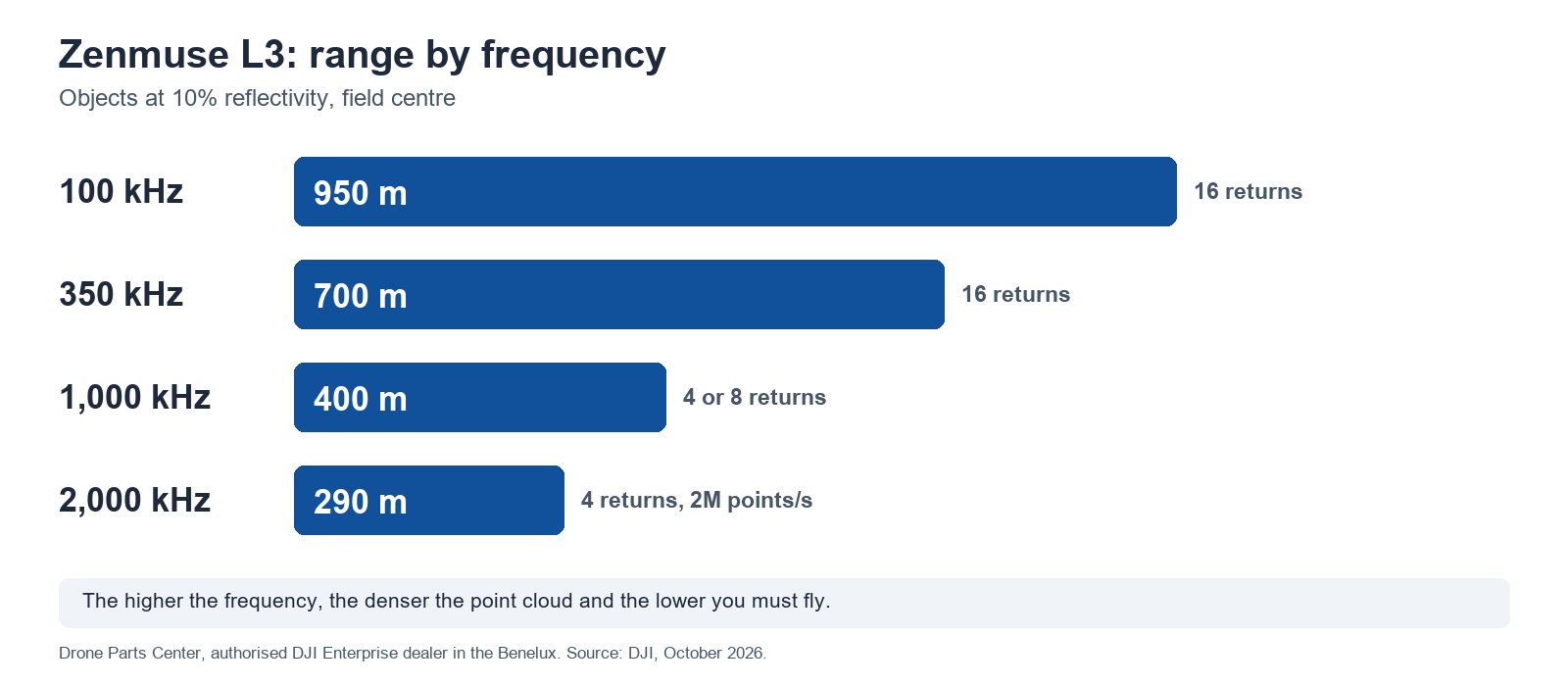
- Range: up to 950 m on objects with 10% reflectivity (at 100 kHz, at the centre of the field of view), so you can fly higher and cover a wider swath.
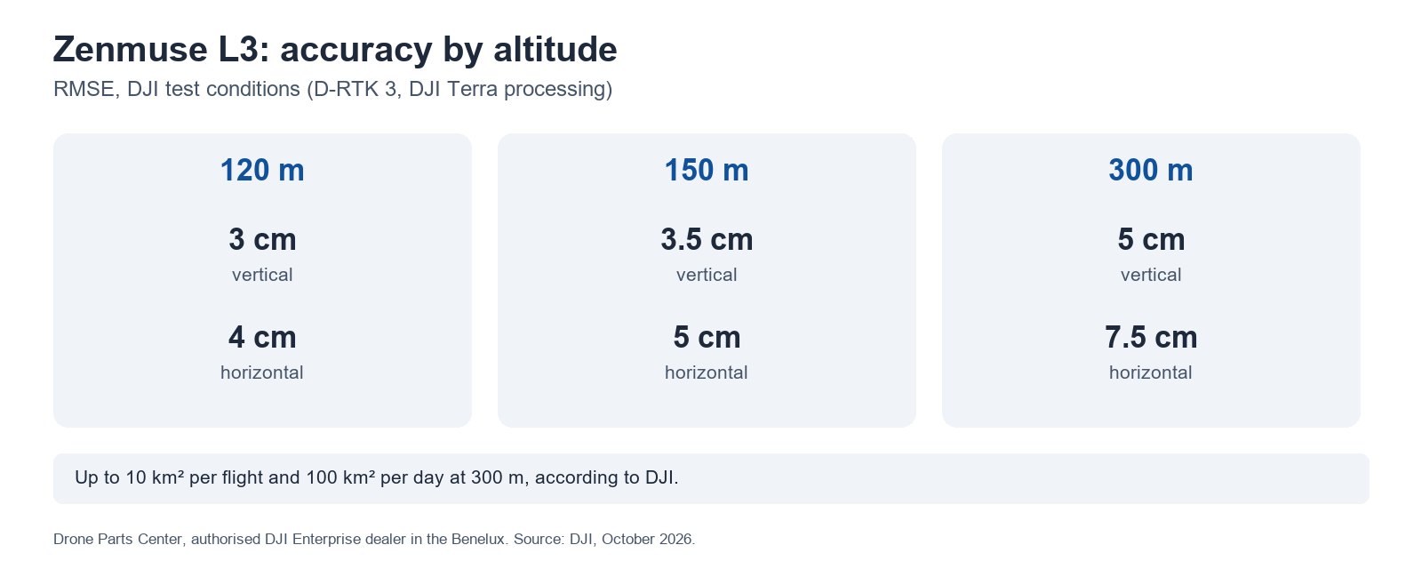
- Accuracy: 3 cm vertical and 4 cm horizontal (RMSE) at 120 m altitude, under DJI’s measurement conditions; DJI cites surveys at scales of 1:500 to 1:2000.
- Penetration: a laser spot about five times smaller than the Zenmuse L2’s (41 mm at 120 m) and up to 16 returns (at 100 and 350 kHz) to reach the ground beneath dense vegetation.
- Efficiency: up to 10 km² in a single flight and 100 km² per day (flat terrain, 300 m altitude, according to DJI), with simultaneous LiDAR and RGB capture.
Built for demanding applications
- Land surveyors: large-scale topographic surveys with less time spent in the field.
- Infrastructure: bridges, roads and power lines. Power Line Follow automatically tracks lines of 10 kV and above.
- Quarries: stockpile volume calculations and extraction monitoring with up-to-date 3D data.
- Forestry and environment: canopy analysis and terrain models beneath vegetation.
Key technical specifications
| Platform | DJI Matrice 400 RTK (IP55, -20 to 50 °C) |
| LiDAR payload | DJI Zenmuse L3 (IP54, 1.60 kg, Class 1 laser) |
| Wavelength | 1,535 nm |
| Range (10% reflectivity) | 950 m at 100 kHz; 700 m at 350 kHz; 400 m at 1,000 kHz; 290 m at 2,000 kHz |
| System accuracy (RMSE) | 3 cm vertical, 4 cm horizontal at 120 m; 5 cm and 7.5 cm at 300 m |
| Point rate | up to 2,000,000 points/s (2,000 kHz mode, below 50 m) |
| Returns | up to 16 (at 100 and 350 kHz) |
| Scanning modes | linear 80° x 3°; star-shaped and non-repetitive 80° x 80° |
| RGB cameras | 2 x 4/3 CMOS, 100 MP (or 25 MP), 107° combined FOV |
| Efficiency | up to 10 km² per flight, 100 km² per day (DJI conditions) |
| Software | DJI Pilot 2, DJI Terra (L3 processing included), DJI Modify, DJI FlightHub 2 |
Data and deliverables
The L3’s RGB cameras deliver a 3 cm GSD even at 300 m altitude, according to DJI. Processing in DJI Terra generates colourised point clouds (LAS, LAZ, PLY and other formats), as well as orthophotos and digital surface models in GeoTIFF, compatible with the main CAD and GIS software. For PPK post-processing, the D-RTK base station must be within 15 km.
Drone Parts Center, authorised DJI Enterprise dealer in the Benelux, configures the kit and trains your pilots. Explore the complete solution for surveying and mapping or request a quote.
Frequently asked questions
Does the Zenmuse L3 work on drones other than the Matrice 400?
No. It mounts only on the DJI Matrice 400, using its dedicated single gimbal connector.
What accuracy can I expect?
According to DJI, 3 cm vertical and 4 cm horizontal (RMSE) at 120 m altitude, with a calibrated D-RTK 3 station and processing in DJI Terra. At 300 m: 5 cm and 7.5 cm.
How much area can I cover?
Up to 10 km² in a single flight and 100 km² per day, over flat terrain at 300 m altitude, under DJI’s measurement conditions.
Can the L3 see through vegetation?
Yes. Its laser spot is about five times smaller than the Zenmuse L2’s and it records up to 16 returns, which increases the number of ground points beneath dense vegetation.
Which software processes the data?
DJI Terra processes L3 point clouds free of charge and produces colourised point clouds, orthophotos and digital models. Data can be exported to the main CAD and GIS software.
Can the kit follow a power line?
Yes, with Power Line Follow, for lines of 10 kV and above. With insulated cables or dense vegetation, DJI recommends switching to manual flight.
Only logged in customers who have purchased this product may leave a review.
1. DJI Matrice 400 Drone
- DJI Matrice 400 × 1
- TB100 × 3 Intelligent Flight Battery
- BS100 Smart Battery Station × 1
- DJI Matrice 400 2510F Propellers × 1 set
- DJI Matrice 400 Gimbal Shock × 1
- DJI Matrice 400 Carrying Case × 1
- Rotating LiDAR Calibration Cover × 1
- Front propeller support × 1
- Rear propeller support × 1
- USB-C to USB-C Cable × 1
- Battery WB37 × 1
- E-Port V2 Port Cover × 2
- Rubber Stopper Screws (2×2) × 4
- Screws and tools × 1
- Cleaning Tools × 1
2. Remote Controls and Accessories
- DJI RC Plus 2 Enterprise Enhanced × 1
- DJI RC Plus 2 sub2G SDR × 1 Module
- DJI RC Plus 2 × 1 Strap Stand Kit
3. Cellular Communications
- Cellular Dongle 2 × 2
- Screwdriver × 1
- Cable Clip × 4
4. Payloads
Zenmuse L3
- Zenmuse L3 × 1
- Lens Cap × 1
- CF Express Card 1 TB × 2
- Storage case × 1
- Cleaning cloth × 1
- CF Express Card Reader × 1
- Gimbal connector for Zenmuse L3 × 1
Related products

In stock
Photogrammetry
In stock
In stock
Photogrammetry
In stock


Reviews
There are no reviews yet.