
 Français
 Nederlands
 Deutsch
Comparisons & Buying Guides, Professional applications
Drone Inspection in 2026: DJI Equipment, Certifications, and ROI for Businesses
Apr
Drone Inspection in 2026: Equipment, Certifications, and ROI for Businesses
Drone inspection reduces costs, eliminates the risk of working at heights, and provides actionable data in real-time. For infrastructure managers, engineering offices and maintenance departments, this is a measurable investment. This guide helps you choose the right equipment and calculate your return on investment.
Types of Drone Inspection
Visual inspection and zoom
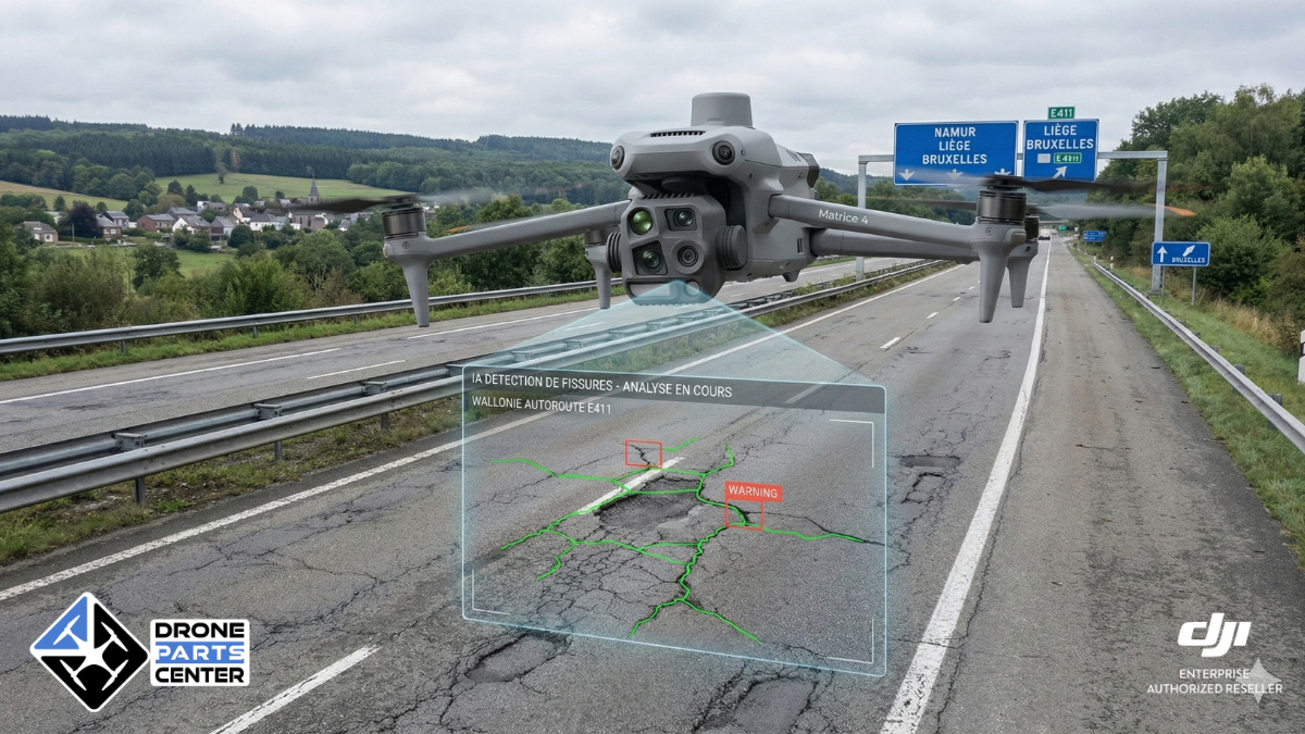
High-resolution visual inspection is the most common assignment. Current inspection drones have cameras with optical zoom of up to 200x on the DJI Matrice 4T, allowing cracks, deformations, corrosion and surface degradation to be detected from a safe distance. Facades, roofs, bridges, pylons and industrial structures are inspected without physical access, eliminating the need for scaffolding or aerial work platforms.
Infrared thermography
The thermal camera detects what the eye does not see: thermal leaks, thermal bridges, insulation defects, water infiltration in flat roofs. For solar parks, it identifies defective cells (hotspots) that reduce the overall efficiency of the installation. On power lines, it identifies abnormal heating before it causes a breakdown.
The DJI Matrice 4T Thermal and Photovoltaic Inspection Pack features an ultra-high-resolution IR camera coupled with 200x optical zoom – the ideal combination for technical inspection offices.
Photogrammetry and 3D modeling
Drone photogrammetry creates 3D models, orthomosaics, and point clouds from high-resolution aerial photos. The DJI Matrice 4E is optimized for this mission with its 61-megapixel CMOS sensor with mechanical shutter, which eliminates rolling shutter distortions when shooting on the move.
Data processing is done via DJI Terra, DJI’s photogrammetry software, or third-party solutions such as Agisoft Metashape or PIX4D. The DJI Matrix 4E + RTK Surveying Pack provides centimeter accuracy for geo-referenced surveys.
LiDAR
LiDAR (Light Detection and Ranging) produces very high density 3D point clouds, even through vegetation. The Zenmuse L3, compatible with the Matrice 400, offers centimeter accuracy for forest mapping, inspection of power lines under vegetation, modeling of linear infrastructure (roads, railways, pipelines) and precision topographic surveys.
Which drone for which inspection?
| Mission | Recommended | DroneSensor | Pricing |
| Building Thermal Inspection | Matrix 4T | IR Thermal + 200x Zoom | On Quote |
| Photogrammetry / | Matrix Mapping 4E | CMOS 61 MP mechanical shutter | On request |
| Quick Inspection / Field Deployment | Mavic 3 Enterprise | Thermal + Focus | On Quote |
| LiDAR / Topography | Matrice 400 + Zenmuse L3 | LiDAR + RGB | On Quote |
| Automated | Recurring Inspection Dock 3 + Matrix 4TD | Multi-Sensors | On Quote |
Typical Inspection Workflow
A drone inspection cycle takes place in six stages:
- Planning: Define the inspection area, points of interest, and flight path in DJI Pilot 2 or FlightHub 2. Configure capture settings (photo intervals, trapping, elevation).
- Flight: execution of the mission in automatic waypoints or manual piloting for areas requiring special attention. The drone follows the predefined route while transmitting the video feed in real time.
- Data collection: simultaneous acquisition of visible, thermal and/or LiDAR images depending on the mission. GPS metadata is embedded in each capture.
- Processing: import of data into DJI Terra, Agisoft Metashape or PIX4D for the generation of deliverables: orthomosaic, 3D model, point cloud, thermal ratio.
- Analysis: identification of anomalies, dimensional measurements, comparison with previous inspections to monitor the evolution of degradation.
- Report: Generation of the customer deliverable: geo-referenced inspection report with precise location of defects, measurements, recommendations, and time comparisons.
Certifications and regulations
The operation of inspection drones in Europe is governed by EASA regulations, transposed in each Member State:
- Open category (A1/A2/A3): for light drones (less than 25 kg) in direct line of sight flight. The Mavic 3 Enterprise (less than 900 g) can operate in sub-category A1 with online training. Class C2 drones (Matrice 4E/4T) require the A2 patent to fly near people.
- Specific category (STS-01/STS-02): for operations in populated areas with drones with a mass greater than 4 kg, or for extended range flights. The STS-01 standard scenario applies to C5-certified drones in populated areas; STS-02 to C6 drones in sparsely populated areas.
- Training required: certificate of theoretical competence (online exam for A1/A3), certificate of practical competence for A2, and specific training for the specific category.
Drone Parts Center offers professional drone training adapted to each level of operation.
Pricing and ROI
Drone inspection offers a measurable economic advantage over traditional methods:
| Method | Average | CostTime | Accuracy | Risk |
| Boom lift + inspector | 2,000-5,000 EUR/day | 1-2 days | Visual | High |
| Thermal Drone | 500-1,500 EUR/day | 2-4 hours | IR + Visual | Low |
| Drone Photogrammetry | 800-2,000 EUR/day | 3-6 hours | Centimeter | Low |
Examples by sector
- Energy: a wind farm manager inspects 10 turbines per day with a 4T Matrice instead of 2 with a nacelle. The cost per turbine is reduced from EUR 1,500 to EUR 300, a reduction of 80%.
- Construction site: site monitoring by photogrammetry (Matrix 4E) generates a weekly orthomosaic that can be used by works supervisors. Cost: 500 EUR per flight compared to 3,000 EUR for a traditional topographic survey.
- Real estate: the thermal inspection of a building with 50 apartments (roof + facades) takes 3 hours with a drone compared to 2 days with a basket. The georeferenced thermal report makes it possible to precisely locate thermal bridges to plan insulation work.
- Linear infrastructure: Inspecting 10 km of track or pipeline takes half a day with a 4T Matrix compared to several days for a pedestrian inspection. Automation via Dock 3 further reduces costs for recurring inspections.
Why choose Drone Parts Center?
Drone Parts Center has been an authorized DJI Enterprise dealer in the Benelux since 2017. Our added value for inspection companies:
- Consulting: Analysis of your needs, recommendation of the optimal configuration, on-site demonstration.
- Sales: Full DJI Enterprise lineup: drones, sensors, software, accessories.
- Training: certification training courses adapted to your sector of activity.
- Maintenance: after-sales service and repair via Drone Clinic, our specialized workshop. More than 380 spare parts in stock.
- Technical support: phone and email assistance, help with FlightHub 2 configuration, SORA support.
- Delivery: Benelux 24h, intra-community invoicing for companies.
Do you want to equip your company for drone inspection? Request a personalized quote