
 Français
 Nederlands
 Deutsch
News, Professional applications
Thermal imaging and DJI drones: revolutionising public safety in 2026
May
L’imagerie thermique s’impose en 2026 comme une technologie incontournable pour la sécurité publique. Face aux limites de la vision humaine et des caméras traditionnelles — obscurité, fumée, camouflage — les drones équipés de caméras thermiques offrent des capacités sans précédent. Drone Parts Center, revendeur agréé DJI Enterprise basé à Nivelles, vous présente les dernières avancées en imagerie thermique embarquée et les solutions drone les plus performantes pour vos missions critiques.
Understanding Thermal Imaging: Seeing the Invisible
Au cœur de l’imagerie thermique réside un principe fondamentalement différent de celui de la photographie classique. Plutôt que de capter la lumière visible réfléchie par les objets, une caméra thermique détecte le rayonnement infrarouge, une forme d’énergie invisible à l’œil nu que tous les corps émettent en fonction de leur température. Plus un objet est chaud, plus il émet de rayonnement infrarouge. Cette capacité à “voir la chaleur” permet aux caméras thermiques de créer des images même dans l’obscurité totale, à travers la fumée légère, le brouillard ou le camouflage qui tromperaient une caméra standard.

Il existe principalement deux types de capteurs thermiques : les capteurs refroidis et les capteurs non refroidis. Les capteurs refroidis, maintenus à des températures cryogéniques, offrent une sensibilité et une précision extrêmes mais sont coûteux, volumineux, énergivores et ont une durée de vie limitée.
À l’inverse, les capteurs thermiques non refroidis fonctionnent à température ambiante. Bien que légèrement moins précis, ils sont nettement plus compacts, légers, abordables, consomment moins d’énergie et bénéficient d’une longévité accrue. Ces caractéristiques en font la technologie de choix pour l’intégration sur des plateformes mobiles comme les drones, où le poids, la taille et l’autonomie sont des contraintes majeures.

Understanding this principle of detecting infrared radiation is essential to understand the power and potential applications of this technology in the field of security.
Les clés d’une image thermique efficace
Obtenir une image thermique exploitable et réaliser une mesure de température précise ne dépend pas uniquement de la qualité intrinsèque du capteur. Plusieurs facteurs externes et paramètres techniques jouent un rôle crucial dans la fiabilité des informations recueillies. La précision thermique peut être affectée par la capacité de la caméra elle-même à dissiper sa propre chaleur, car le bruit thermique interne peut interférer avec les mesures. Les conditions atmosphériques sont également déterminantes : l’humidité, la pluie, la neige, la fumée ou la poussière peuvent atténuer le rayonnement infrarouge et fausser les lectures. L’émissivité, qui décrit la capacité d’une surface à émettre de l’énergie thermique, et la réflectivité, sa capacité à réfléchir le rayonnement thermique ambiant, sont des propriétés intrinsèques des matériaux observés qui influencent grandement la mesure de température.
Au-delà de la mesure de température, la capacité à distinguer les détails dans l’image thermique, ou résolution spatiale, est essentielle pour l’identification des cibles. Deux concepts clés entrent en jeu : l’IFOV (Instantaneous Field of View), qui représente le plus petit détail qu’un seul pixel peut “voir” à une distance donnée, et le GSD (Ground Sample Distance), qui traduit cette résolution en une dimension réelle au sol (par exemple, centimètres par pixel). Un IFOV ou un GSD plus petit signifie une meilleure résolution et donc une image plus détaillée, permettant de mieux distinguer les formes.
Pour standardiser l’évaluation des performances de détection, le concept DRI (Détection, Reconnaissance, Identification) est largement utilisé.

La Détection correspond à la distance maximale à laquelle un objet devient visible comme une source de chaleur distincte.
La Reconnaissance est la distance à laquelle on peut classer l’objet (humain, véhicule, animal).
L’Identification est la distance à laquelle des détails plus fins peuvent être discernés (type de véhicule, personne armée ou non).
Understanding these notions of DRI, coupled with IFOV and GSD, makes it possible to estimate the optimal operational distance for a given mission, ensuring efficient thermal detection, target recognition and thermal identification.

Drones thermiques DJI en 2026 : la nouvelle génération
DJI reste en 2026 le leader incontesté des drones thermiques professionnels. La gamme 2025-2026 marque un bond technologique majeur avec la série Matrice 4, qui remplace les modèles précédents (Mavic 3T, Matrice 30T) tout en offrant des performances supérieures à un prix compétitif.
DJI Matrice 4T — Le thermique compact (6 899 €)
Le DJI Matrice 4T succède au Mavic 3T en intégrant un capteur thermique 640×512 pixels dans un format ultra-compact. Avec sa caméra grand-angle, son zoom optique et son télémètre laser, il offre un déploiement rapide pour les missions de reconnaissance thermique, d’inspection et de recherche de personnes. Son format compact en fait l’outil idéal pour les premiers intervenants qui ont besoin d’une capacité thermique immédiate.
DJI Matrice 4TD — La référence sécurité publique 2026 (8 830 €)
Le DJI Matrice 4TD est le drone thermique le plus avancé de sa catégorie. Certifié IP55 (pluie, poussière, vent jusqu’à 12 m/s), il embarque un capteur thermique 640×512, un zoom optique 56× et offre 42 minutes d’autonomie. Sa compatibilité avec le DJI Dock 3 permet un déploiement automatisé 24h/24 en mode Drone as First Responder (DFR). C’est la plateforme de référence pour les zones de police, les pompiers et la protection civile en Belgique et au Luxembourg.
DJI Matrice 400 RTK + Zenmuse H30T — Le multi-capteurs ultime (32 574 €)
Pour les missions exigeant une portée et des capacités maximales, le DJI Matrice 400 RTK – Public Safety Triple Payload Kit embarque simultanément 3 charges utiles : la nacelle thermique Zenmuse H30T (caméra thermique 640×512, zoom optique 40×, télémètre laser 1 200 m), un projecteur et un haut-parleur. Avec 59 minutes d’autonomie et un positionnement RTK centimétrique, c’est la solution la plus complète pour les unités d’intervention spécialisées et les opérations SAR de grande envergure.
Accessoires thermiques complémentaires
Complétez vos capacités d’intervention avec nos accessoires dédiés :
- DJI AS1 Speaker (229 €) — haut-parleur compact pour sommations vocales
- DJI Zenmuse V1 (950 €) — haut-parleur longue portée pour le Matrice 400
- DJI AL1 Spotlight (299 €) — projecteur compact pour éclairage de zone
- DJI Zenmuse S1 (1 300 €) — projecteur haute puissance pour opérations nocturnes
Au-delà du matériel, DJI propose l’écosystème logiciel DJI Thermal Analysis Tool, un outil puissant pour analyser a posteriori les images et données thermiques collectées, extraire des mesures de température précises et générer des rapports détaillés. Le logiciel DJI FlightHub 2 centralise la gestion de flotte et le streaming vidéo en direct, permettant aux centres de commandement de superviser plusieurs drones simultanément.

Revolutionary applications in public safety
The true value of drones equipped with thermal imaging is revealed in the diversity and impact of their applications in the field. These technologies offer new capabilities and significantly improve the efficiency of operations in several critical areas of public safety.
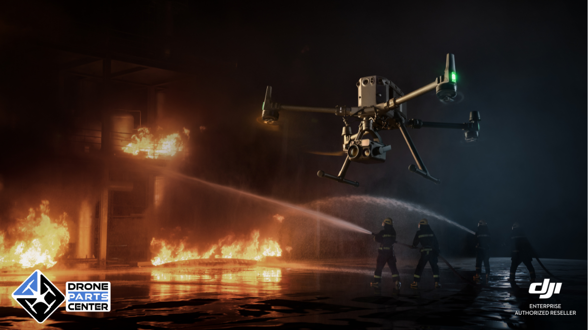
Firefighting: Seeing Through the Smoke
Pour les sapeurs-pompiers, l’imagerie thermique embarquée sur drone est une révolution. Lors d’incendies urbains ou industriels, elle permet de percer l’épaisse fumée pour localiser précisément les foyers principaux ou “points chauds”, d’évaluer l’intégrité structurelle des bâtiments en détectant les zones de faiblesse thermique, et de guider les équipes d’intervention au sol en leur fournissant une vue d’ensemble tactique inestimable. Dans le contexte des feux de forêt, les drones thermiques sont essentiels pour surveiller les lisières, détecter les reprises de feu latentes invisibles à l’œil nu, cartographier l’étendue réelle du sinistre et optimiser l’allocation des ressources.

Des fonctionnalités spécifiques comme les différentes palettes de couleurs (adaptées pour percer la fumée ou identifier des signatures thermiques spécifiques), les isothermes (qui colorent spécifiquement une plage de température, utile pour repérer des corps humains par exemple) et la mesure précise de température à distance sont des atouts majeurs. Notre Pack Pompiers & Secours DJI Matrice 4TD (9 199 €) intègre tous ces outils dans une solution clé en main prête à l’emploi.
Policing: Surveillance and Discreet Intervention
Les forces de l’ordre — police et gendarmerie — bénéficient grandement des drones thermiques pour leurs missions de surveillance et d’intervention. La capacité à opérer de jour comme de nuit, en toute discrétion, permet une surveillance efficace de zones étendues, de sites sensibles ou d’événements majeurs. L’imagerie thermique excelle dans la localisation de suspects qui tenteraient de se dissimuler dans l’obscurité, la végétation ou même sous certains types de camouflage léger. Elle facilite également le suivi de véhicules en fuite grâce à la signature thermique laissée par le moteur et les pneus.

Le zoom 56× du Matrice 4TD permet d’observer des détails à grande distance sans se faire repérer, tandis que les isothermes alertent automatiquement les opérateurs de la présence d’une signature thermique correspondant à une personne. Notre Pack Intervention Police DJI Matrice 4TD (9 199 €) est spécialement configuré pour ces missions. Découvrez comment les drones révolutionnent les opérations policières →
Search and Rescue (SAR): Recovering Lives
Dans les opérations de recherche et sauvetage (SAR), chaque minute compte. Les drones thermiques sont devenus des alliés indispensables pour accélérer la localisation de victimes. Qu’il s’agisse de retrouver une personne disparue en forêt la nuit, un randonneur égaré en montagne, ou des survivants après une catastrophe naturelle (séisme, inondation, avalanche), la caméra thermique peut détecter la chaleur corporelle même dans des conditions de visibilité nulle ou à travers une végétation dense.
Cela permet aux équipes de la protection civile et aux sauveteurs de concentrer leurs efforts sur les zones les plus probables et de réduire considérablement le temps de recherche, augmentant ainsi les chances de survie des personnes recherchées. Selon l’étude conjointe EENA, Black Channel et DJI, les équipes équipées de drones localisent les victimes jusqu’à 80 % plus rapidement que les patrouilles classiques. Découvrez nos solutions drones de secourisme →
Industrial Safety: Preventing Risks
Au-delà des missions d’urgence, l’imagerie thermique par drone trouve des applications précieuses dans le domaine de la sécurité industrielle et de la maintenance prédictive. Elle permet d’inspecter rapidement et en toute sécurité des infrastructures étendues ou difficiles d’accès, comme les lignes électriques haute tension, les parcs de panneaux solaires, les pipelines, ou les façades de grands bâtiments.

La caméra thermique peut détecter des anomalies invisibles à l’œil nu, telles que des composants électriques en surchauffe, des défauts d’isolation, des fuites de fluides ou de gaz, ou des infiltrations d’humidité. Cette capacité d’inspection thermique précoce permet d’identifier les risques potentiels avant qu’ils ne conduisent à des pannes coûteuses, des accidents ou des interruptions de service.
Dock 3 et DFR : l’imagerie thermique autonome 24h/24
Le concept de Drone as First Responder (DFR) représente l’avenir de l’imagerie thermique en sécurité publique. Avec le DJI Dock 3, compatible Matrice 4TD, un drone thermique décolle automatiquement en moins de 60 secondes dès réception d’un appel au 112 — bien avant l’arrivée de la première patrouille. Le drone survole la zone, transmet des images thermiques en direct au dispatching et permet une évaluation immédiate de la situation : localisation de suspects, détection de victimes, évaluation d’un incendie.
Plusieurs zones de police en Europe déploient déjà le DFR pour la surveillance thermique 24h/24 de zones sensibles. Le Dock 3 gère le décollage, la mission et le rechargement de manière totalement autonome. Découvrez nos solutions Drone In the Box.
Bonnes pratiques et précautions d’usage
Pour tirer le meilleur parti des drones thermiques et garantir la fiabilité des données ainsi que la longévité du matériel, il est essentiel d’adopter certaines bonnes pratiques. Le choix de l’équipement doit avant tout être guidé par les besoins de la mission : un modèle compact comme le Matrice 4T sera privilégié pour des déploiements rapides, tandis que le Matrice 400 RTK avec la nacelle H30T sera nécessaire pour des missions de longue durée exigeant une portée et une sensibilité thermique maximales.
It is crucial to understand the inherent limitations of the technology and the environmental factors that can influence measurements, such as distance, humidity, or surface reflectivity, in order to correctly interpret thermal images.
La maintenance du capteur thermique lui-même requiert une attention particulière. Il faut impérativement éviter d’exposer l’objectif de la caméra thermique à des sources d’énergie intenses telles que le soleil direct, la lave, ou des faisceaux laser. Une telle exposition peut causer des dommages irréversibles au capteur, se manifestant par des artefacts permanents sur les images (phénomène de “sun burn”). La plupart des drones DJI intègrent une protection logicielle qui ferme automatiquement l’obturateur infrarouge en cas de détection de lumière solaire intense, mais la vigilance reste de mise.

Enfin, maîtriser les différentes fonctionnalités logicielles est indispensable pour optimiser l’utilisation de la caméra thermique : savoir choisir la palette de couleurs la plus adaptée au scénario (par exemple, “White Hot” ou “Black Hot” pour la recherche de personnes, “Iron Red” pour la détection de points chauds dans les incendies), ajuster le mode de gain (High Gain pour la précision, Low Gain pour une plage de température plus large), effectuer régulièrement une calibration (FFC – Flat-Field Correction) pour optimiser la qualité d’image, et utiliser judicieusement le zoom numérique ou le zoom lié (Link Zoom) qui synchronise le zoom des caméras visible et thermique.

Following these good practices for the use and maintenance of the thermal sensor ensures safer operations and more reliable results.
Nos packs sécurité avec imagerie thermique
Drone Parts Center propose des solutions complètes, prêtes à voler, intégrant l’imagerie thermique la plus performante du marché :
- Pack Intervention Police M4TD (9 199 €) — drone thermique IP55 + accessoires + configuration opérationnelle pour les forces de l’ordre
- Pack Pompiers & Secours M4TD (9 199 €) — configuration optimisée pour la détection thermique de personnes et la lutte incendie
- Matrice 400 RTK – Public Safety Triple Payload Kit (32 574 €) — solution multi-capteurs ultime pour les interventions les plus exigeantes
Découvrez toute notre gamme Sécurité & Secours.
Pourquoi choisir Drone Parts Center ?
- Revendeur agréé DJI Enterprise en Belgique et au Luxembourg, basé à Nivelles
- Expertise terrain — plus de 10 zones de police belges déjà équipées en drones thermiques
- SAV et réparation via notre Drone Clinic certifiée
- Formation pilote professionnel adaptée aux missions de sécurité — catalogue formations
- Conformité réglementaire — conforme EASA et DGTA pour les opérations en catégorie Spécifique
- Couverture Benelux — livraison, installation et support dans toute la Belgique, le Luxembourg et les Pays-Bas

Obtenez votre devis personnalisé
Vous êtes responsable d’une zone de police, d’un service d’incendie, de protection civile ou d’une unité d’intervention en Belgique ou au Luxembourg ? Nos experts vous conseillent la solution thermique la mieux adaptée à vos missions et à votre budget.
→ Demander un devis gratuit pour votre drone thermique
Articles connexes
- Drone police prix en 2026 : guide complet pour équiper vos unités
- Drones de secourisme : recherche et sauvetage en 2026
- Découvrez toute notre gamme Sécurité & Secours