
 Français
 Nederlands
 Deutsch
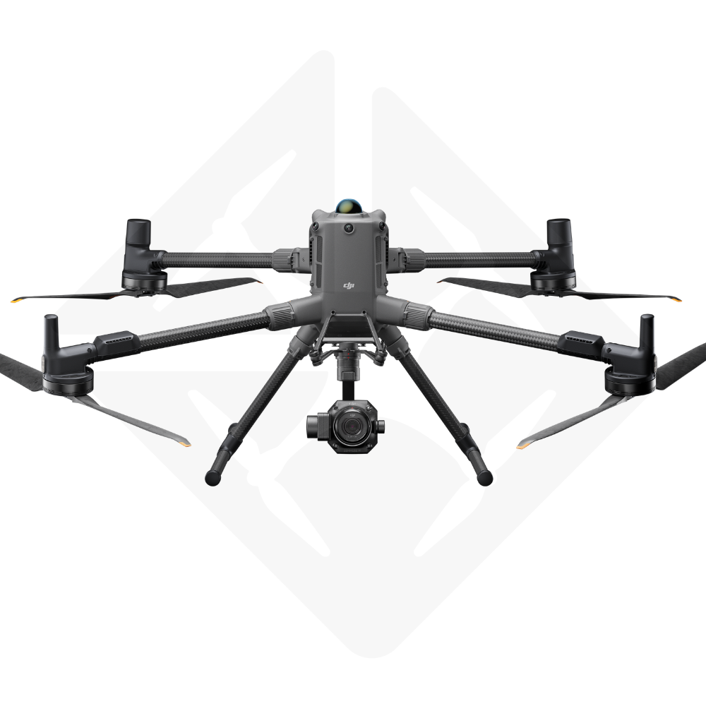

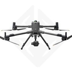
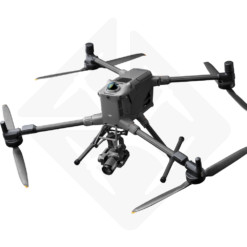
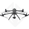
DJI Matrice 400 RTK – Surveying P1 Kit
€ 21.839,00
The reference kit for surveying and drone inspection.
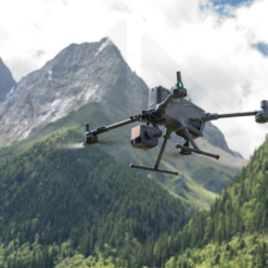
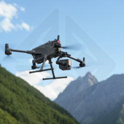
The DJI Matrice 400 RTK – Surveying P1 Kit is the ultimate integrated solution for surveyors, inspection companies, and quarry operators demanding centimeter accuracy and maximum operational efficiency. Combine the power and endurance of the Matrice 400 RTK drone with the full-frame photogrammetric performance of the Zenmuse P1 camera for unmatched surveys, engineering inspections, and 3D modeling.
- DJI Matrice 400 RTK drone: 59 min flight time, 360° obstacle detection, IP55.
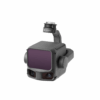
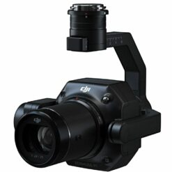
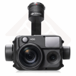
- Zenmuse P1 camera: 45 MP full-frame sensor, mechanical shutter, interchangeable lenses.
- RTK accuracy: Achieve accuracy of 3 cm (horizontal) and 5 cm (vertical) without ground control points.
- Applications: Topography, cadastre, inspection of bridges and roads, monitoring of quarries, 3D modelling.
In stock
DJI Matrice 400 RTK with Zenmuse P1: The New Era of Aerial Photogrammetry
Enter a new dimension of productivity and accuracy with the DJI Matrice 400 RTK – Surveying P1 Kit. Designed for professionals who make no compromises, this bundle combines DJI’s most advanced flight platform with an exceptional photogrammetric camera. It redefines the standards of geospatial data collection for surveyors, civil engineers and critical infrastructure managers.
Unmatched Efficiency for Demanding Missions
The DJI Matrice 400 RTK (M400 RTK) is a real technological workhorse. With a flight time of up to 59 minutes and a payload capacity of 6 kg, it is designed to cover large areas and complete missions without interruption. Its maximum flight speed of 25 m/s and wind resistance of 12 m/s ensure stable performance even in harsh conditions, a major asset for bridge inspections or surveys in exposed areas.
The Zenmuse P1 camera, at the heart of this kit, is the ultimate photogrammetry tool. With its 45 MP full-frame sensor and overall mechanical shutter, it captures images with exceptional sharpness and clarity, eliminating distortion even at high speeds. The Smart Oblique Capture function automatically optimizes oblique shots, increasing post-processing efficiency by 20-50%.
Effortless Centimeter Accuracy
Forget the constraint of ground control points (GCPs). Thanks to the Matrice 400’s high-precision RTK module and TimeSync 2.0 technology, this kit achieves absolute accuracy of 3 cm horizontally and 5 cm vertically. TimeSync 2.0 synchronizes the camera, flight controller and RTK module in real time to the microsecond, ensuring the most reliable geo-referenced data with every shot.
Designed for Surveyors, Inspectors and Quarry Operators
This kit has been specifically assembled to meet the needs of your trade:
- Surveyors and Topographers: Perform 1:500 scale cadastral and topographic surveys faster than ever before. Cover up to 3 km² in a single flight for accurate 2D orthomosaics and 3D models.
- Roads and Bridges Inspection Companies: Inspect infrastructure safely with omnidirectional obstacle detection, including LiDAR and mmWave radar that can identify even power lines. Get ultra-high-resolution images of vertical surfaces for detailed structural analysis.
- Quarries and Mines: Track inventory changes, measure volumes, and plan operations with reliable, up-to-date 3D data collected quickly and securely.
Key Technical Specifications
| Characteristic | DJI Matrice 400 RTK | DJI Zenmuse P1 |
|---|---|---|
| Max. take-off weight | 15.8 kg | Approx. 800 g |
| Max | 59 minutes | N/A |
| Ingress protection | IP55 | IP4X |
| RTK Accuracy (Fix) | Horizontal: 1 cm + 1 ppm Vertical: 1.5 cm + 1 ppm |
Accuracy without GCP: 3cm H / 5cm V |
| Camera Sensor | Starlight 1080p | Full-frame 35.9×24 mm |
| Effective | N/A | 45 MP |
| Compatible | N/A | 24/35/50mm (DJI DL) |
| Shutter | N/A | Mechanical: 1/2000s – 1s |
| Obstacle | Omnidirectional (Vision + LiDAR + mmWave Radar) | N/A |
Frequently Asked Questions (FAQs)
Can the DJI Matrice 400 RTK fly in the rain?
Yes, the aircraft has an IP55 rating, which allows it to fly in moderate rain (up to 100mm/24h). However, the protection can decrease with wear and tear, so it is advisable to be careful.
What are the benefits of the Zenmuse P1’s mechanical shutter?
The overall mechanical shutter eliminates the “rolling shutter” effect, which is crucial for photogrammetry. It allows sharp images to be captured even at high speeds, ensuring greater accuracy of 3D models and orthophotos.
Is it necessary to use Ground Control Points (GCPs)?
No. Thanks to the combination of RTK and TimeSync 2.0, the kit can achieve centimeter accuracy without the need for GCP, saving a lot of time and cost in the field.
Which software is compatible for data processing?
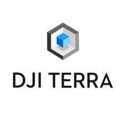
The data collected by the Zenmuse P1 is fully compatible with DJI Terra, which offers an integrated processing solution. They can also be processed by the main photogrammetry software on the market such as Pix4D, Agisoft Metashape, etc.
Only logged in customers who have purchased this product may leave a review.
1. DJI Matrice 400 Drone
- DJI Matrice 400 × 1
- TB100 × 3 Intelligent Flight Battery
- BS100 Smart Battery Station × 1
- DJI Matrice 400 2510F Propellers × 1 set
- DJI Matrice 400 Gimbal Shock × 1
- DJI Matrice 400 Carrying Case × 1
- Rotating LiDAR Calibration Cover × 1
- Front propeller support × 1
- Rear propeller support × 1
- USB-C to USB-C Cable × 1
- Battery WB37 × 1
- E-Port V2 Port Cover × 2
- Rubber Stopper Screws (2×2) × 4
- Screws and tools × 1
- Cleaning Tools × 1
2. Remote Controls and Accessories
- DJI RC Plus 2 Enterprise Enhanced × 1
- DJI RC Plus 2 sub2G SDR × 1 Module
- DJI RC Plus 2 × 1 Strap Stand Kit
3. Cellular Communications
- Cellular Dongle 2 × 2
- Screwdriver × 1
- Cable Clip × 4
4. Payloads
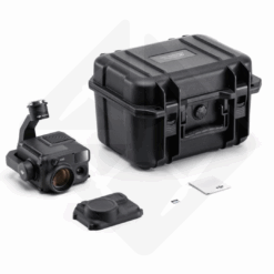
Zenmuse P1
- Zenmuse P1 × 1
- Lens Cap × 1
- 128GB SD Card × 1
- Storage case × 1
- Cleaning cloth × 1
- DJI DL Lens 35mm × 1
- Activation code for DJI Terra × 1
Related products

Photogrammetry
Available to order (please contact us)

Reviews
There are no reviews yet.