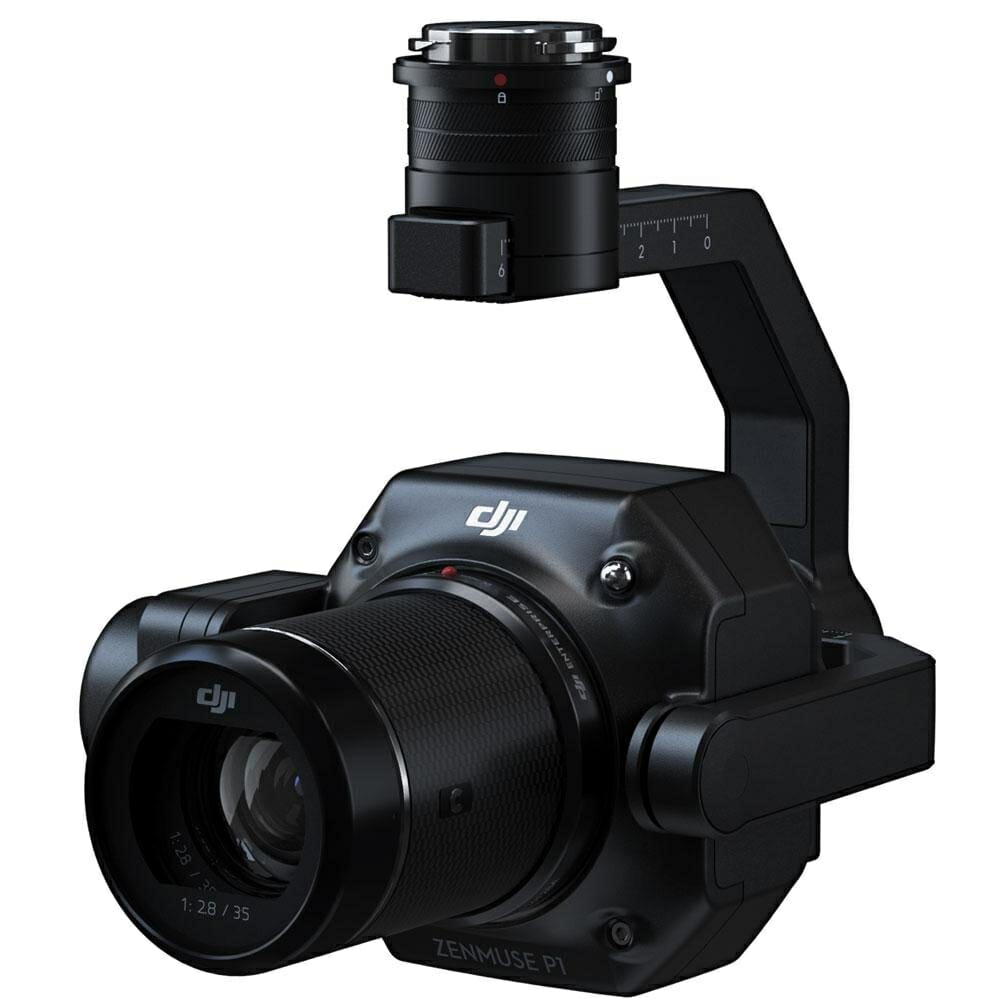
DJI Zenmuse P1
€ 5.999,00
Discover the DJI Zenmuse P1. Capture high-precision data with this advanced aerial camera designed for exceptional results.
Available to order (Please contact us)
DJI Zenmuse P1 is designed for photogrammetry flight missions, it supports functions such as intelligent oblique capture and real-time mapping. When mounted on the DJI M300 RTK UAV, it can collect orthomosaic data from 10 square kilometers in just 4 flights, or 140 minutes, taking efficiency and accuracy to a whole new level.
Equipped with a 45 Megapixel full format CMOS sensor, the Zenmuse P1 is compatible with the DJI Matrix 300 RTK UAV and DJI PL lenses. It is based on a 3-axis stabilized gondola.
This camera allows to reach a precision and a resolution unequalled until then at DJI. Designed for 3D modeling missions, its sensor allows to model with fidelity a 3D environment.
The DJI Zenmuse P1 camera allows, thanks to post-processing, the creation of orthophotos, in point clouds or in high-precision 3D models.
It is supplied with a 35 mm lens.
Smart Oblique Capture for intelligent operations
Exceptional mapping efficiency. You can shoot a larger area with a single battery or the modelling accuracy will be higher than before. With one set of batteries, it is possible to map an area of 7.5 km2 (at a GSD of 3 cm). High efficiency is achieved by shooting in five different directions in a single "sweep". In this case, the distance to be covered is significantly reduced and, in addition to oblique images, vertical images at 90 degrees are also obtained for modelling.
It may be necessary to replace the battery if the area to be mapped is very large or if you want to achieve very high accuracy. Thanks to the fast hot swab technology , the helicopter is not switched off and the helicopter is back in the air in less than a minute. During a traditional battery replacement, the connection to the RTK / VRS GNSS network (Geotrim Trimble) is lost. This slows down the shooting and brings uncertainty to the continuity.
Intelligent oblique capture. Cover 7.5 km2 in a single day's work with the P1. Increase the efficiency of your oblique photography mission with Smart Oblique Capture, where the gimbal automatically rotates to take photos at the different angles needed. Only the photos needed for reconstruction will be taken at the edge of the flight area, increasing post-processing efficiency by 20% to 50%.
Fieldwork report. Check the quality of the data immediately after the flight by verifying the position data and the number of images acquired, as well as the RTK status and positioning accuracy.
2D ortho-mosaic mission. Effortlessly acquire oblique images from multiple angles that meet 3D modelling requirements in all sectors, such as urban planning and centimetre-accurate cadastral surveys to serve 3D reality models and intelligent urban planning.
3D Oblique Mission. Effortlessly acquire oblique images from multiple angles that meet 3D modelling requirements in all sectors, such as urban planning and centimetre-accurate cadastral surveying to serve 3D reality models and intelligent urban planning.
Detailed modelling mission. Acquire ultra-high resolution image data of vertical or sloping surfaces at a safe distance that faithfully recreates fine textures, structures and features, for detailed reconstructions, geological studies, conservation of heritage sites, hydraulic engineering, etc.
Real-time mapping mission. Collect geographic information from large areas in real time using DJI Terra so that teams can quickly make critical decisions on site.
Applications:
- Topographic mapping. Topography / geo-computing and mapping. Capture data that meets accuracy requirements at 1:500 scale without GCP.
- AEC and surveying. Manage the entire project lifecycle with highly accurate point clouds and 3D models.
- Energy and infrastructure. Energy infrastructure and power distribution and power lines. Model sparse or complex structures in detail to manage them safely and efficiently.
- Cadastral surveying. 3D modelling. Quickly generate 3D reality models accurate to the centimetre.
- Natural resource management. Monitoring natural resources. Measuring, classifying or determining ownership of water bodies and forests.
- Geological research. Safely collect millimetre-accurate aerial data of geologically hazardous sites.
- Disastersite modelling. Investigate, document and map the accident site. Get real-time overviews of large disaster areas to help teams make critical decisions.
Technical information:
Camera
- 45MP full frame sensor - 4.4 μm pixel size
- Low noise, high sensitivity Imaging extends daily operating time
- Take a picture every 0.7s during flight
- TimeSync 2.0 aligns camera, flight controller
- RTK module, and gimbal at the microsecond level
Product name: Zenmuse P1
Dimensions: 198 × 166 × 129 mm
Weight: approx. 787 g
Power: 13 W
IP rating: IP4X
Supported aircraft: Matrix 300 RTK
Operating temperature range: -20° to 50°C (-4° to 122°F)
Storage temperature range: -20 ° to 60 ° C (-4 ° to 140 ° F)
Absolute accuracy: horizontal: 3 cm, vertical: 5 cm
Using the mission mapping at a GSD of 3 cm and a flight speed of 15 m/s, with a forward overlap rate of 75% and a lateral overlap rate of 55%.
Camera details
Sensor size (Fixed): 35.9 × 24 mm (Full frame)
Sensor size (Maximum video recording area): 34 × 19 mm
Effective Pixels: 45MP
Pixel size: 4.4 μm
Supported lenses:
DJI DL 24mm F2.8 LS ASPH, FOV 84
DJI DL 35mm F2.8 LS ASPH, FOV 63.5
DJI DL 50mm F2.8 LS ASPH, FOV 46.8
All lenses include a lens hood and a balancing ring/filter
Supported cards: SD: UHS-1 rating or higher;
Maximum 128GB storage files: GNSS raw observation data / Image log file
Photo size: 3: 2 (8192 × 5460)
Operating modes: Capture, Record, Playback
Minimum photo interval: 0.7 s
Mechanical shutter speed: 1 / 2000-1 / 8 s
Electronic shutter speed: 1 / 8000-8 s
Aperture range: f / 2.8-f / 16
ISO range Photo: 100-25600
ISO range Video: 100-3200
Video format: MP4
Video resolution: 16: 9 (3840 × 2160)
Frame rate: gimbal 60fps
Stabilized system: 3-axis (tilt, roll, pan)
Angular vibration range: 0.01
Mounting: detachable DJI SKYPORT
Mechanical range:
Tilt: -125 ° to + 40 °; Roll: -55 ° to + 55 °; Pan: ± 320 °
Only logged-in customers who have purchased this product can leave a review.
Similar products
Propellers
6 in stock
1 in stock
DJI Enterprise
Available to order (Please contact us)
Autel Robotics
Available to order (Please contact us)
Available to order (Please contact us)
Building and infrastructure inspection
Inspection and Measurement Pack by Drone DJI Mavic 3 Enterprise.
Available to order (Please contact us)


Notice
There's no notice yet.